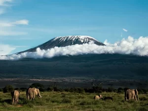
9 DAY NORTHERN CIRCUIT ITINERARY
Day 1
Londorossi Gate to Mti Mkubwa
Elevation: 7,742 ft. to 9,498 ft.
Distance: 6 km/4 miles
Hiking Time: 3-4 hours
Habitat: Rain Forest
We depart Moshi for Londorossi Gate, which takes about 4 hours, where you will complete entry formalities. Then drive to the Lemosho trailhead. Upon arrival at trailhead, we begin hiking through undisturbed forest which winds to the first camp site.
DAY 2
Mti Mkubwa to Shira 1 Camp
Elevation: 9,498 ft to 11,500 ft
Distance: 8 km/5 miles
Hiking Time 5-6 hours
Habitat: Heath
We continue on the trail leading out of the rain forest and into a savannah of tall grasses, heather and volcanic rock draped with lichen beards. As we ascend through the lush rolling hills and cross several streams, we reach the Shira Ridge before dropping gently down to Shira 1 Camp. Here we catch our first glimpse of Kibo across the plateau.
DAY 3
Shira 1 Camp to Shira 2 Camp
Elevation: 11,500 ft to 12,500 ft
Distance: 7 km/4 miles
Hiking Time: 3-4 hours
Habitat: Heath
We explore the Shira Plateau. It is a gentle walk east on moorland meadows towards Shira 2 Camp. The heath zone displays abundant wildflowers and unique Senecio trees.
DAY 4
Shira 2 Camp to Lava Tower
Elevation: 12,500 ft to 15,190 ft
Distance: 7 km/4 miles
Hiking Time: 3-4 hours
Habitat: Alpine Desert
Lava Tower to Moir Hut
Elevation: 15,190 ft to 13,580 ft
Distance: 7 km/4 miles
Hiking Time: 2-3 hours
Habitat: Alpine Desert
We continue to the east up a ridge and then head southeast towards the Lava Tower – a 300 ft tall volcanic rock formation. Then we divert from the main trail to Moir Hut, a little used site on the base of Lent Hills. A variety of walks are available on Lent Hills making this an excellent acclimatization opportunity. Shira Plateau is one of the highest plateaus on earth.
DAY 5
Moir Hut to Buffalo Camp
Elevation: 13,580 ft to 13,200 ft
Distance: 12 km/7 miles
Hiking Time: 5-7 hours
Habitat: Alpine Desert
We trek out of Moir Valley with a moderately steep climb, then hike to the summit of Lent Hills before returning to the main trail. The path crosses a rock field and gently undulates before reaching Buffalo Camp. This section of the trail offers great views across the plains that lie north of Kilimanjaro and stretch out to the Kenyan/Tanzanian border.
DAY 6
Buffalo Camp to Third Cave
Elevation: 13,200 ft to 12,700 ft
Distance: 8 km/5 miles
Hiking Time: 5-7 hours
Habitat: Heath
As we head up Buffalo Ridge, the terrain becomes increasingly sparse. This route is rarely travelled and we will enjoy its mountain wilderness feel. We trek through remote valleys on to the northern slopes of Kilimanjaro until we arrive at Third Cave.
DAY 7
Third Cave to School Hut
Elevation: 12,700 ft to 15,600 ft
Distance: 5 km/3 miles
Hiking Time: 4-5 hours
Habitat: Alpine Desert
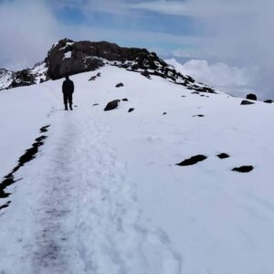
We climb steadily up and over the “Saddle,” which sits between Kibo and Mawenzi. We continue on to our camp, School Hut. Once here we rest, enjoy an early dinner to prepare for the summit day.
DAY 8
School Hut to Uhuru Peak
Elevation: 15,600 ft to 19,341 ft
Distance: 6 km/4 miles
Hiking Time: 6-8 hours
Uhuru Peak to Mweka Camp
Elevation: 19,341 ft to 10,065
Distance: 12 km/7 miles
Hiking Time: 4-6 hours
Habitat: Artic
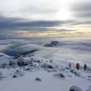
Very early in the morning (around midnight), we begin our push to the summit. This is the most mentally and physically challenging portion of the trek. The wind and cold at this elevation and time of day can be extreme. We ascend in the darkness for several hours while taking frequent, but short, breaks. At Gilman’s point (18,600 ft), you will be rewarded with the most magnificent sunrise you are ever likely to see coming over Mawenzi Peak. Finally, we arrive at Uhuru Peak- the highest point on Mount Kilimanjaro and the continent of Africa.
From the summit, we now make our descent continuing straight down to the Mweka Hut camp site, stopping at Barafu for lunch. The trail is very rocky and can be quite hard on the knees; trekking poles are helpful. Mweka Camp is situated in the upper forest and mist or rain can be expected in the late afternoon. Later in the evening, we enjoy our last dinner on the mountain and a well-earned sleep.
DAY 9
Mweka Camp to Mweka Gate
Elevation: 10,065 ft to 5,380 ft
Distance: 10 km/6 miles
Hiking Time: 3-4 hours
Habitat: Rain Forest
On our last day, we continue the descent to Mweka Gate and collect the summit certificates. At lower elevations, it can be wet and muddy. From the gate, we continue another hour to Mweka Village. A vehicle will meet us at Mweka Village to drive us back to the hotel in Moshi.